Showing posts with label Maps. Show all posts

Friday, February 26, 2010

Where's the content?

Highly politicized map of Bessarabia, from the 1930 edition of the Malaya Sovetskaia Entsiklopediia.
[source: Wikipedia]

It's hard to believe I have neglected this space for three solid months now.  Things have been quite busy, and now we're about to enter another transitional period which might make it easier for me to devote more time to blogging but more likely will not.

Therefore, with the thought that this might be the "front-page" post for at least a few weeks, I thought I'd give a rundown of what I've been reading/watching/looking at online, with the assumption that of course if I've found it interesting, you will as well.

The interesting, insidery blog Diplopundit points out a recent blog post by U.S. Ambassador to Russia John Beyrle that made something of a splash, and Russian politicians (and their aides) are also capable of making news these days with nothing more than a click of the "post" button:
ADVISER TO RUSSIAN SPEAKER CALLS FOR RECOGNITION OF MOLDOVA'S BREAKAWAY REGION
Ren TV, privately-owned Russian television channel, Feb. 18, 2010

A statement that could cause a new large international scandal - in his blog today, an adviser to the chairman of the Federation Council of Russia, Aleksandr Chuyev, expressed the opinion that it is time for Russia to recognize the independence of the Dniester region, following Abkhazia and South Ossetia.

Interestingly, this statement coincided with the statements by Igor Smirnov, leader of the Dniester republic, which broke away from Moldova, according to which they are prepared to accept Russian Iskander missiles and other armaments.
Other recent stories about Transnistria have ranged from disappointing to optimistic (and another), and from nutty to nuttier.

Some blogs to read while this one lies dormant:

- The Russia Monitor, which Jesse has turned into a must-read resource.
- Siberian Light - lots on there recently for you sports fans, or sport fans, as I guess they say here in the UK.
- Sean's Russia Blog - Sean's still got it, and now that he is in Russia the posts are even better.
- Robert Amsterdam - comprehensive as always.
- Window on Eurasia - just check it out (especially this post on fake NGOs).
- Poemless - opinionated, in a good, entertaining way.
- A Good Treaty - an interesting NKOTB, which came to my attention via Poemless.
- Morning in Moldova - for those interested in keeping current on developments there.

Other worthwhile reads - the long but engrossing Vanity Fair piece chronicling the rise and fall of the Exile, and (from the dead-tree realm) Keith Gessen's New Yorker piece on the Ukrainian elections and Yushchenko's failures (full text not available online w/o subscription), which captures Ukraine's dilemmas, from the profound to the ridiculous:
[Quoting Leonid Shvets:] 'But Ukraine was a historical actor, and how! I have a friend, one of his grandfathers was in the Galician S.S. and died fighting, and his other grandfather was in the Red Army and made it all the way to Berlin.  What do you do with that?  Politicians should stay away from it.  They should look to the future.' [...]

Yanukovych's people were taking no chances.  If there was an initiative to be seized by taking to the streets, they were going to be the ones to seize it.  The...square filled up with Yanukovych 'supporters.'  A television crew on the scene conducted interviews.  Many supporters were drunk, and men in Yanukovych jackets began cutting off interviews before they began.  But they didn't manage to reach one angry woman in time.  'We've been here since 5 a.m., and they still haven't paid us!' she said.  'It's outrageous!'  It was an interesting moment in post-Soviet life: a paid participant in a street action meant to fool the media was appealing to the media for justice, because she had not been paid.
Poking around online to check prices of antique maps, I happened upon Wikipedia's surprisingly content-rich "Atlas of Moldova" page (the source for the illustration above).

I also noticed a Moldovan connection while watching the Winter Olympics (well, not really, my sister clued me in) - apparently, one of the U.S. ice dancing pairs used a song for their routine that was identified as a "Moldavian Folk Dance."  NBC makes the video content from the Games somewhat challenging to access, but there are a couple of YouTube clips showing the duo using the routine in previous competitions.  Predictably, the comments on both YouTube clips are taken up in large part by arguments over whether this is a Romanian melody or a Moldovan one. 

On a more serious note, I've been spending some time remembering my father, who passed away ten years ago this weekend, thanks to some material that has appeared online recently about the work he was doing before I was in the picture (see also this recently posted four-part article - part 1, part 2, part 3, part 4). 

And what could be a better soundtrack for such reminiscences than this classic song (an even more old-school video is here)?

Tuesday, August 25, 2009

"A Soviet Fly in Geopolitical Amber"


Strange Maps provides a dandy headline phrase describing Transnistria, as well as an detailed map of the region. I have a similarly fascinating poster-sized map of Moldova with various demographic breakdowns and migration statistics, but unfortunately I have no way to scan in such a big piece of paper.

Here's a recent update on the prospects for conflict resolution (if you can get past the tired phrases like "it could be a museum of the Soviet Union"), and here's a great resource if you are looking for further reading on the subject - three volumes of essays on the conflict which were presented at a conference that I attended in late May.

Here are some photos of Tiraspol, Transnistria's capital, from my most recent trip there on June 18 of this year:


CIMG3392, originally uploaded by lyndonk2.
HQ of the local youth organization, Proryv (Breakthrough).


CIMG3391, originally uploaded by lyndonk2.
Billboard of Russian President Medvedev and Transnistrian leader
Igor Smirnov - the banner at left reads "Our strength is in unity with Russia!"


CIMG3385, originally uploaded by lyndonk2.
Decidedly old-school advertising posters outside of the Officers' Club,
which now rents some of its space to other organizations - unfortunately
I wasn't able to photograph the incredible, museum-like display of portraits
of historical Russian military figures which adorns one of the large rooms inside.


CIMG3381, originally uploaded by lyndonk2.
Inside the HQ of the Transnistrian Communist Party (not a huge vote-getter, but - according to the party's leader - a
genuine opposition party, although according to others I spoke with if they threaten the authorities too much then they
might face a mud-slinging campaign based on their earlier contacts with the Moldovan Communist Party)


CIMG3378-1, originally uploaded by lyndonk2.
Recruiting poster for the Felix Dzerzhinsky (!) boarding school for cadets, which prepares 5th- to 9th-graders
for a career in the local police or internal troops - the appeal is to "Duty, Honor, Fatherland" - MacArthuresque!

Monday, August 17, 2009

The Caucasus in 1842


Caucasus1842, originally uploaded by lyndonk2.

This is the latest in an ongoing series of Caucasus maps (note that some other maps will probably also be caught by the "Maps" label, but most are from this endlessly interesting part of the world).

Friday, July 24, 2009

Map of 1993 fighting in Georgia


I'm not sure how accurate this map is (I found it on Wikipedia, a website which is often a good reminder that you get what you pay for), but it's interesting and I decided to post it in keeping with my practice of posting maps, especially maps of the Caucasus. Full-sized version can be found here.

Thursday, April 16, 2009

A Map With a Story to Tell

I know this isn't particularly substantive, but please bear with me. Perhaps the coolest thing I was able to bring back from my most recent trip to Chisinau was the map taxi drivers - at least Russophone taxi drivers - use to get around the city. I've seen it used before, and the cabbie I ended up buying it from told me there was a place where I could buy a copy, but since I was leaving the next day I prevailed on him to sell me his.

The map with one fell swoop eliminates all of my questions about why some cabbies in Chisinau still use Soviet-era street names. The reason, quite apparent if you look at the full-size images of the pages below (here and here), is that the map itself is replete with Soviet-era names. In all (I've reproduced below only the title page and the page showing downtown), it's a riot of names of offices and restaurants in two languages and two alphabets - exactly the sort of thing that makes Moldova such a fascinating place to visit when you have somewhere else to go home to, but can make it a challenging place to live when you don't.


IMG_1381, originally uploaded by lyndonk2.


IMG_1380, originally uploaded by lyndonk2.

Thursday, January 15, 2009

The Caucasus in 1927 - "New Political Boundaries"


Caucasus 1927, full-sized version available here.

Wednesday, December 10, 2008

More fun with maps

Regular readers will recall my summertime practice of scanning in and posting maps, mostly of the Caucasus and various regions thereof - see the photoset here and previous map-themed posts here.

Recently I've been taking advantage of London's status as the center of the world's antique maps trade and have been checking out some of the offerings. The two maps below are not exactly antique - they are from Harmsworth's Atlas, n.d. but variously dated as 1919-1923 - but they are pretty interesting. The first appears to show the brief period after WWI during which the states of the South Caucasus were independent. The second shows that Romania within its current borders (much less its interwar borders) is a relatively recent phenomenon and that when it comes to the notion of redrawing borders in that part of the world, just about any group can select a long-ago date to use as a reference point that would give it more than what it has today.


Caucasia, view full-sized version here.


Romania Historical, view full-sized version here.

Thursday, August 21, 2008

More Maps of Georgia

A couple more maps that I had the chance to scan in before leaving DC last week. Complaints about the white line through the larger images can be directed to the folks at A.U.'s library, although since they make an otherwise nice scanner fairly freely accessible I didn't have the heart to complain. The first is a map of tourist routes through Georgia which dates from 1966:


Georgia - Tourism Map 1966 - Cover, full-size image available here.


Georgia - Tourism Map 1966, full-size image available here.


The second is a city map of Tbilisi with a nifty folding layout, printed (according to the guy who sold it to me in Tbilisi) for the city's 1500th anniversary celebration in 1958; I am not sure about the "800" imprinted on the cover:


Tbilisi - 1958 Street Map Cover, full-size image available here.


Tbilisi - 1958 Street Map, full-size image available here.


This and all previous map-related posts can be seen on a single page here, or all of the map images I've uploaded can be viewed on Flickr here.

Wednesday, July 23, 2008

More maps of the Caucasus

A friend of mine who's based in Tbilisi has emailed me these four maps: three interesting German maps of the changing political geography of the Caucasus (sorry, I don't know the source or copyright holder), and a fourth one (also quite interesting in its own way) which goes more toward the present-day situation in a small part of the region.


Histrorical Georgia 1774-1878, full-size version available here.


Histrorical Georgia 1917-1936, full-size version available here.


Histrorical Georgia 1936 - 1959, full-size version available here.


South Ossetia Areas of Control (geor-SO), full-size version available here.
Areas controlled by South Ossetian de facto authorities in red, areas controlled by Georgia in blue.
Here's one good backgrounder on the conflict, and here's another fairly interesting brief.

More maps of the Caucasus, as well as my general disclaimer about how, while I think the old maps are fascinating, I'm also convinced they are a fairly unhelpful lens through which to view the resolution of current territorial conflicts, can be seen here.

Friday, July 11, 2008

Even more Caucasus maps

I found one last book with scan-worthy inlaid maps in my attic archives - Kavkazskii Krai - Putevoditel' (Caucasus Territory - Guidebook) by Sergei Anisimov, from 1928. The book's largest and perhaps most spectacular map - a map of Caucasus tourism routes - is something I'm still trying to stitch together from four digital files, since the original was too big to scan in one piece, even on a large flatbed scanner. But the ones which scanned in easily are still quite lovely and - as with many artifacts of the Caucasus - susceptible to being invested with all kinds of meaning.


The coolest of the maps I was able to scan in would have to be this map of Caucasus transit routes, which bristles with all kinds of quaint station-names, including Tikhoretskaya, a station made famous as the destination of the train in the beautiful and haunting song sung variously by Alla Pugacheva in the classic movie "Irony of Fate" (Ironiia Sud'by) (a subtitled video of the song from the movie, with Barbara Bryl'ska lip-synching to Pugacheva's singing, is at 7:45 of this clip (part of a medley of songs from the movie, the second part of which is here) and a clip of just the song, without subtitles, is here) and by Vladimir Vysotsky.


[update July 15]

Another interesting thing about this map is that it shows the state of railways in Abkhazia in the 1920s - when there wasn't a single line in the region. Wikipedia has more on the history of Abkhazian rail transport. The rail line through the region has of course has cropped up as a relevant point in the conflict resolution talks (and as the subject of a few interesting online photo essays documenting the crumbling infrastructure) a number of times over the years and has more recently become a convenient excuse for Russia to increase its troop presence in the region.

[/update]

Also of interest is this map of the Caucasus' always controversial ethnography. This 1928 snapshot is the sort of thing that proponents of secession in Abkhazia and South Ossetia like to roll out to verify (perhaps not without justification) that "once upon a time, these lands were ours." Often this is accompanied by the tongue-twisting - and often mind-bendingly employed - word "autochthonous."

This map of the Caucasus' geological zones is perhaps interesting in its own right, but I found the most interesting aspect of it to be that it measures longitude in degrees from Pulkovo.

And I'm including this map of Tbilisi Tiflis mainly because it is a cool-looking, old-timey map, which is ultimately the spirit that motivates much of my map-scanning, although I am sure one could do an interesting analysis of the street names - which ones had already been changed by the Soviets by the late 1920s, which ones would later be changed, etc.


Kavkazskii Krai - Tiflis Map, full-size version here.

See all of the maps I've posted here.

Thursday, June 12, 2008

The one that got worked out

Here is a map of a region in Georgia that is no longer a conflict zone. In the late Shevardnadze era (i.e., the early 2000's), Tbilisi's tenuous control over Ajaria (a.k.a. Adzharia, Adjara, Achara) was often mentioned in the same breath as the de facto independence of Abkhazia and South Ossetia as evidence of Georgia's failed statehood.

Relatively soon after the Rose Revolution, however, in May 2004, Ajaria's wily ruler Aslan Abashidze, who had run the province pretty much as a personal fiefdom since the Soviet breakup, was ousted from his perch in Batumi and forced to flee - to Moscow, I believe, to take advantage of the hospitality of his pal Yuri Luzhkov, who had earlier tried unsuccessfully to insert himself as a mediator in the conflict between Batumi and the Georgian center.

The only real tragedy of Abashidze's ouster was the sad fate of his many fancy dogs. The departure of the long-time leader did not fully quiet the dissatisfaction of the local population, however, and the fact that it was accomplished without violence may have fostered an early and unjustified sense of confidence among Saakashvili's team that the other regions which had strayed even farther from Tbilisi's control would somehow be easy to bring back into the fold. The region retains nominal autonomous status, which it also enjoyed during the Soviet era.

Anyway, here's a map of the region made in less chaotic times - circa 1985:


Achara Side 2, originally uploaded by lyndonk2; full-size version here.


Achara Side 1, originally uploaded by lyndonk2; full-size version here.

Please be patient, and don't worry...

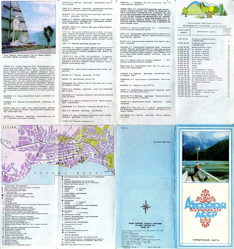
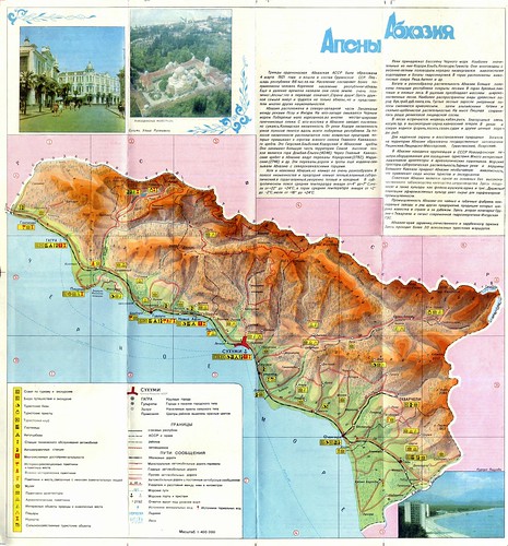
...I'm running out of maps to post, in case you've grown weary of the ongoing series. It's not my intention to make this blog a repository for examples of Soviet cartography. But hopefully at least a few readers find all of these vintage maps of the Caucasus to be of interest. This one is a mid-1980s folding map of Abkhazia:


Abkhazia-Side2, originally uploaded by lyndonk2; full-size version here.


Tuesday, June 10, 2008

Black Sea Coast of the Caucasus

This map took much longer than I'd care to admit to scan in, since it had to be scanned in bits and then digitally assembled - and I don't really have the proper software for that, so sadly I had to use the very basic MS Paint. I might have given up if the thing wasn't so visually spectacular. It dates from 1970 and has thumbnail photos and brief summaries of tourist attractions on the back.

Through sometimes painful experience, I've concluded that Flickr is a better photo host than Blogger, so I've uploaded the images there - if you want to see larger-sized versions, click on the picture or the link underneath it and then once you have been taken to Flickr, look for the "all sizes" icon above the photo. I've also added a link to the very largest version of each image in the captions below.


BlackSeaCoastMap, originally uploaded by lyndonk2; full-size version here.


BlackSeaCoastMap-Back, originally uploaded by lyndonk2; full-size version here.

Sunday, June 08, 2008

Another Abkhazia-related map

Continuing my recent spate of posts about Abkhazia, here is another map I found in one of our boxes of stuff from Moscow, most likely purchased at Izmailovo or some other flea market - a tourist's guide to Sukhumi from the early 1980s. I scanned it in at a fairly high resolution, so if you click on the images and view the full-sized files you should be able to read the narrative text describing the city's various tourist attractions.


Thursday, June 05, 2008

More on Abkhazia

I'm not in a position to try to follow the breaking aspects of the story and provide updates on the escalation or de-escalation of tensions, various visits to the region by foreign dignitaries, etc., but I did want to post a few more maps as well as point out that the International Crisis Group has just issued a report on the situation in Abkhazia. I haven't read it yet, but if it's anything like their past reports on the conflict it will be interesting and useful. I normally skim over the "recommendations" portions of their reports and head to the meatier narrative portions, which contain insights from interviews conducted by ICG which you might not see elsewhere.

As for the maps, I've scanned them in from a book I recently acquired, Konflikty v Abkhazii i IUzhnoi Osetii: Dokumenty 1989-2006 gg. I was expecting a dry compilation of documents and perhaps some black-and-white maps - imagine my surprise when the book arrived with two inlaid full-color maps and maps on each of the endpapers.

The book is published in Moscow and at least one of the maps appears to have been authored by a relative of Abkhazia's de facto leader Sergei Bagapsh, so it is quite possible that the maps are designed to make subtle and perhaps deceptive political points (this is also suggested by the somewhat tendentious title of the second map - rough translations of the map titles appear as captions below).

Nevertheless, they are so well-designed that I couldn't resist posting them (though I'll be happy to take them down if the copyright holders object!), and I would imagine that at least the ones based on 1989 figures are reliable. The map titled "peacekeeper deployment" also contains ethnic breakdown figures, but they are based on the questionable 2002 census figures arrived at by the de facto Abkhazian authorities.

Click on the images to expand them:

Ethnic minorities in Georgia (based on the 1989 census)

Ethnic minorities within (the internationally recognized borders of) Georgia
(based on 2002 figures)

Abkhazia: an ethnic map based on the 1989 census

Republic of Abkhazia and peacekeeper deployment

Friday, May 30, 2008

More on my favorite topic

I heard an extensive and pretty even-handed report about Abkhazia on NPR's Morning Edition today. I guess that means it's finally "arrived" as a mainstream news topic - that, or they are trying to inform their listeners before open hostilities break out there.

In the meantime, I've been reorganizing some of my old books* which have been languishing in boxes since we moved back to DC from Moscow - the reorganization is in preparation for our move later this year to London, although we won't be taking these books with us. Before re-boxing them, I took some quick photos of a few of the books and the maps of the region therein which might be of interest to Caucasophiles (photos are of book covers and then one map from each of the books):


Caucasus Travel Guide, c. 1929


Schematic map of agriculture, industry, oil pipelines,
electrification, and railroads planned and under construction


Georgian Military Highway, 1925


Map of the Transcaucasian SFSR


Abkhazian Alps, 1930


Schematic map of the eastern portion of the Black Sea coast


* Please note that all of these books were exported from Russia with the appropriate permission from the Ministry of Culture!